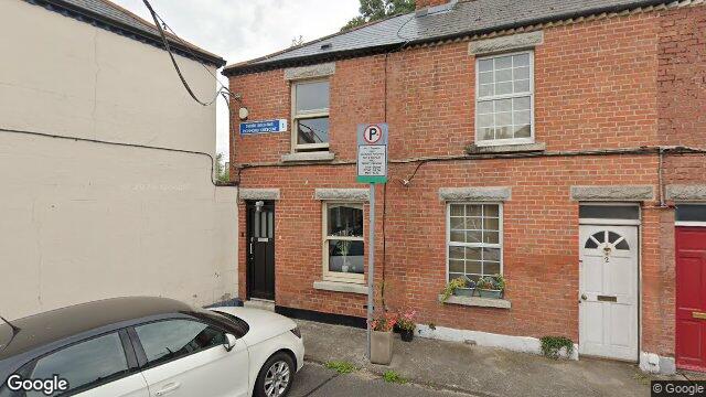
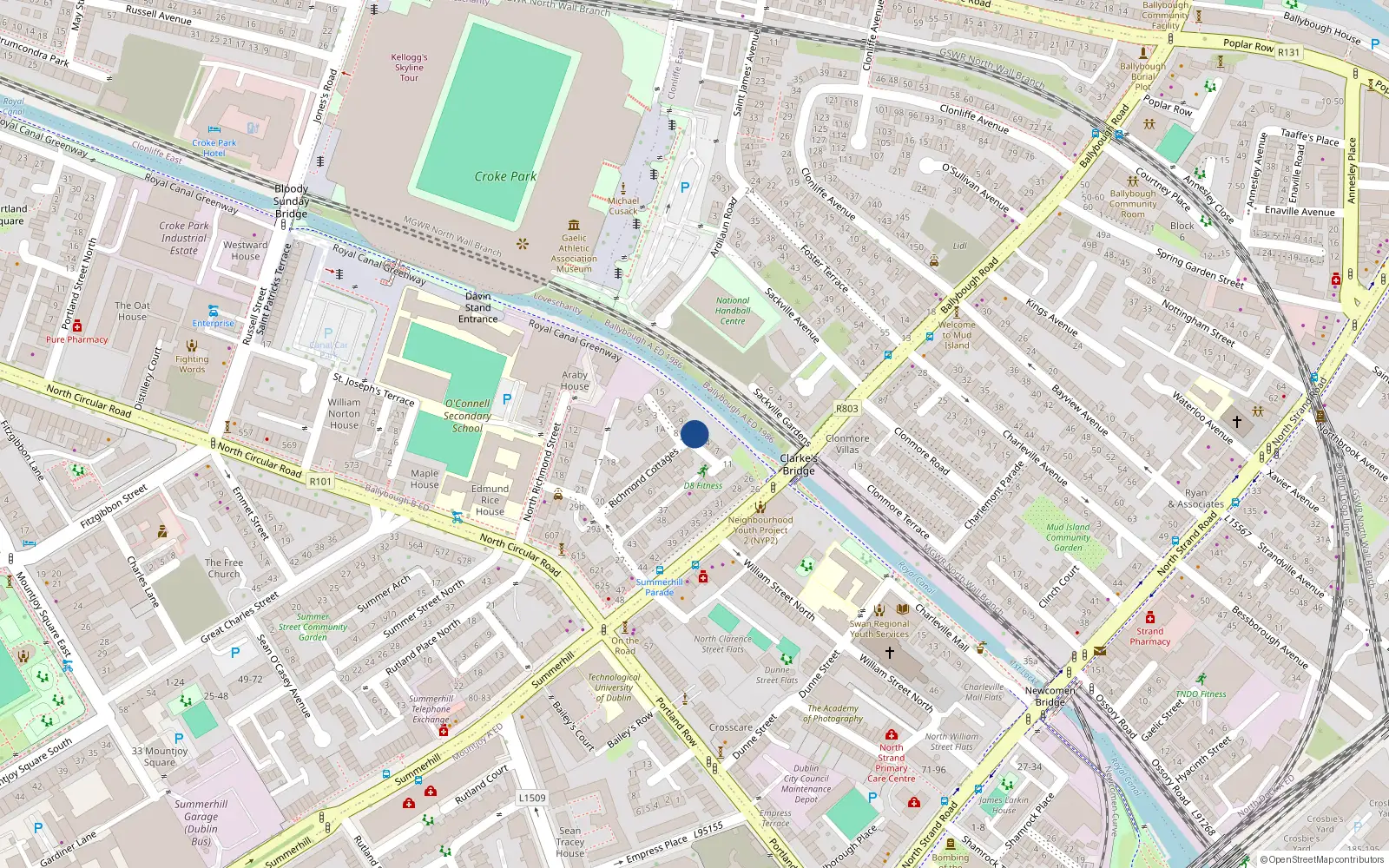
1 Richmond Crescent

Dublin 1 / Drumcondra / D01C8Y4

Last Sale Price

€385,000
House Second-Hand 1 recorded sale
vs Street
+45.3%
Median €265,000
2 sales
(limited data)
vs Drumcondra
+25.0%
Median €308,000
69 sales
Growth +5.2%/yr · 12.8 yrs
vs Dublin 1
+40.0%
Median €275,000
3,909 sales
Growth +6.3%/yr · 15.2 yrs
Nearby Properties
Loading map…

Sale History

1 sale
€385,000
4 yrs, 2 mo ago
Second-Hand Dwelling house /Apartment

Price Intelligence

This property has one recorded sale for €385,000 on 16 Dec 2021.

Area Rank
Top 32%
of 69 properties
What did 1 Richmond Crescent last sell for?

1 Richmond Crescent last sold for €385,000 on 16 Dec 2021.

How does 1 Richmond Crescent compare to the rest of Drumcondra?

Compared to Drumcondra (median €308,000, 69 sales), 1 Richmond Crescent sits 25.0% above the area average.

Growth metrics use repeat-sale properties only. Methodology.

Drumcondra streetscape

About Drumcondra

Drumcondra is a neighbourhood in Dublin 1, Dublin.

Area Median
€308,000
69 sales
District Median
€275,000
3,909 sales
Street Median
€265,000
2 sales

Housing in Dublin 1

Typical Size
57 m²
Typical Build
1999
BER Ratings
A (efficient)G

Based on 11,162 BER assessments — see district details

Related Pages

Debug: Address & Geocode Data

Composed Display Address

1 Richmond Crescent, Off Ballybough Road, Dublin 1

PPR Source

address 1 RICHMOND CRESCENT, OFF BALLYBOUGH RD, DUBLIN 1
canonical_address 1 RICHMOND CRESCENT, OFF BALLYBOUGH RD, DUBLIN 1
eircode (PPR) D01C8Y4
property_id 3432b9c67afc360dc7db1ebaef6a21a8e4554f0f
region dublin-01
format_display_address() 1 Richmond Crescent, Off Ballybough Road, Dublin 1

Parsed Address (URL Gen)

district dublin-01
district_display Dublin 1
area drumcondra
area_display Drumcondra
street richmond-crescent
street_display Richmond Crescent
house_number 1
slug 1-richmond-crescent-off-ballybough-rd
is_apartment false

Geocode Data

source_provider google
source_accuracy APPROXIMATE
latitude 53.3584541
longitude -6.248645499999999
formatted_address Drumcondra, Dublin, Co. Dublin, D01 C8Y4, Ireland
eircode (geocode) D01C8Y4
locality Dublin
county County Dublin
resolution_method conflict_unresolved_google_default
street_number
route
sublocality
address_components
show raw JSON
[{"long_name": "D01 C8Y4", "short_name": "D01 C8Y4", "types": ["postal_code"]}, {"long_name": "Drumcondra", "short_name": "Drumcondra", "types": ["neighborhood", "political"]}, {"long_name": "Dublin", "short_name": "Dublin", "types": ["locality", "political"]}, {"long_name": "County Dublin", "short_name": "D", "types": ["administrative_area_level_1", "political"]}, {"long_name": "Ireland", "short_name": "IE", "types": ["country", "political"]}]

Provider Geocode Payloads

Google ok
query_text D01C8Y4, Ireland
fetched_at 2026-02-18T13:45:13Z
formatted_address Drumcondra, Dublin, Co. Dublin, D01 C8Y4, Ireland
eircode D01C8Y4
locality Dublin
county County Dublin
street_number
route
sublocality
latitude 53.3584541
longitude -6.248645499999999
address_components
show raw JSON
[
  {
    "long_name": "D01 C8Y4",
    "short_name": "D01 C8Y4",
    "types": [
      "postal_code"
    ]
  },
  {
    "long_name": "Drumcondra",
    "short_name": "Drumcondra",
    "types": [
      "neighborhood",
      "political"
    ]
  },
  {
    "long_name": "Dublin",
    "short_name": "Dublin",
    "types": [
      "locality",
      "political"
    ]
  },
  {
    "long_name": "County Dublin",
    "short_name": "D",
    "types": [
      "administrative_area_level_1",
      "political"
    ]
  },
  {
    "long_name": "Ireland",
    "short_name": "IE",
    "types": [
      "country",
      "political"
    ]
  }
]
raw_payload
show raw JSON
{
  "accuracy": "APPROXIMATE",
  "address_components": [
    {
      "long_name": "D01 C8Y4",
      "short_name": "D01 C8Y4",
      "types": [
        "postal_code"
      ]
    },
    {
      "long_name": "Drumcondra",
      "short_name": "Drumcondra",
      "types": [
        "neighborhood",
        "political"
      ]
    },
    {
      "long_name": "Dublin",
      "short_name": "Dublin",
      "types": [
        "locality",
        "political"
      ]
    },
    {
      "long_name": "County Dublin",
      "short_name": "D",
      "types": [
        "administrative_area_level_1",
        "political"
      ]
    },
    {
      "long_name": "Ireland",
      "short_name": "IE",
      "types": [
        "country",
        "political"
      ]
    }
  ],
  "country_code": "ie",
  "county": "County Dublin",
  "eircode": "D01C8Y4",
  "formatted_address": "Drumcondra, Dublin, Co. Dublin, D01 C8Y4, Ireland",
  "lat": 53.3584541,
  "locality": "Dublin",
  "lon": -6.248645499999999,
  "place_id": "ChIJTVsHlWEOZ0gRILKa1LbBWpU",
  "provider": "google",
  "route": "",
  "street_number": "",
  "sublocality": ""
}
Nominatim ok
query_text D01C8Y4, Ireland
fetched_at 2026-02-13T00:26:07Z
formatted_address National Library of Ireland, 7/8, Kildare Street, Mansion House B Ward 1986, Dublin, County Dublin, Leinster, D02 P638, Éire / Ireland
eircode D02P638
locality Dublin
county County Dublin
street_number 7/8
route Kildare Street
sublocality
latitude 53.3411249
longitude -6.2545
address_components
show raw JSON
{
  "ISO3166-2-lvl5": "IE-L",
  "ISO3166-2-lvl6": "IE-D",
  "amenity": "National Library of Ireland",
  "city": "Dublin",
  "city_district": "Mansion House B Ward 1986",
  "country": "\u00c9ire / Ireland",
  "country_code": "ie",
  "county": "County Dublin",
  "house_number": "7/8",
  "postcode": "D02 P638",
  "region": "Leinster",
  "road": "Kildare Street"
}
raw_payload
show raw JSON
{
  "accuracy": "library",
  "address_components": {
    "ISO3166-2-lvl5": "IE-L",
    "ISO3166-2-lvl6": "IE-D",
    "amenity": "National Library of Ireland",
    "city": "Dublin",
    "city_district": "Mansion House B Ward 1986",
    "country": "\u00c9ire / Ireland",
    "country_code": "ie",
    "county": "County Dublin",
    "house_number": "7/8",
    "postcode": "D02 P638",
    "region": "Leinster",
    "road": "Kildare Street"
  },
  "country_code": "ie",
  "county": "County Dublin",
  "eircode": "D02P638",
  "formatted_address": "National Library of Ireland, 7/8, Kildare Street, Mansion House B Ward 1986, Dublin, County Dublin, Leinster, D02 P638, \u00c9ire / Ireland",
  "lat": 53.3411249,
  "locality": "Dublin",
  "lon": -6.2545,
  "place_id": "256017403",
  "provider": "nominatim",
  "route": "Kildare Street",
  "street_number": "7/8",
  "sublocality": ""
}

Composition Path

Formatted address cleaned formatted_address (stripped ", Ireland" and Eircode)

Eircode Resolution

PPR eircode D01C8Y4
Geocode eircode D01C8Y4
best_eircode (used) D01C8Y4

BER Data (no BER match)

No BER data matched for this property.

Computed Metrics

property_type Second-Hand
dwelling_type House
size_description None
holding_years None
annualized_pct None
vs_street_median_pct 45.3
street_median 265000
street_sample_size 2
street_is_reliable false
vs_area_median_pct 25.0
area_median 308000
area_sample_size 69
area_is_reliable true
vs_district_median_pct 40.0
district_median 275000
district_sample_size 3909
district_is_reliable true
street_growth_rate_pct None
street_growth_years None
street_growth_sample_size 0
area_growth_rate_pct 5.2
area_growth_years 12.8
area_growth_sample_size 7
district_growth_rate_pct 6.3
district_growth_years 15.2
district_growth_sample_size 371
nearby_avg_price None
nearby_price_range None
nearby_count 0